Sunday, October 13, 2013

Another Nice Fall Day in the Mountains


I was going to do a Bandelier Loop today, but decided to take advantage of moderate temperatures and the fact that I overdressed and so headed up the mountain instead. It really was a glorious ride.

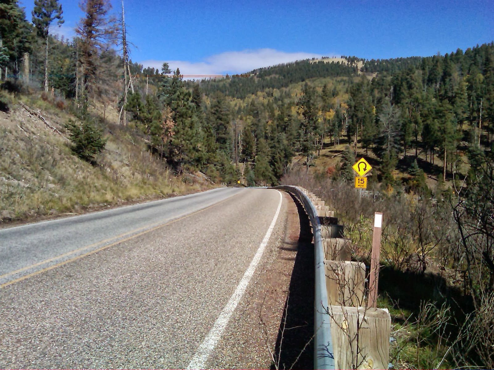
Start of ~7-8% descent back towards Los Alamos 
from the top of the Jemez climb.
Lest anyone think my recent screed about Strava was a damnation of spirited riding, it is anything but that. The bottom line is to have fun but consider one's responsibility to the public, if not to one's own skin. NM4 on the Bandelier Loop and up in the mountains has a dearth of crosswalks, downhill "bombs" into busy intersections in the Castro District, or school zones to contend with. One's principle worries are excessive speed (such that you lose control, overcook a curve, or god forbid, get a ticket), gravel, F150's, "surprises", especially on blind curves (such as bloggers stopping along the side of the road to take pictures), or herds of elk and deer suddenly crossing the road in front of you. I've seen or heard of all of that and more--this is anything but a closed course. So control your bike, don't force anyone else to do something risky to save your careless ass, and have a good time. Be aware though, that good ascenders can gain minutes on adversaries to the seconds gained, at considerable risk, by good descenders hell-bent on making up time. 

As far as online counts of who is beating whom in online competitions, I can assure you that some of the local folks logging times on the Strava site can probably lap me on the Bandelier course in one loop. But unless one is racing under identical conditions, its not clear to me what having the "best time" really means when it comes to close competitions. Does it mean you had a tailwind and I had a headwind? Who the hell knows...its all about enjoying the ride and enjoying honest competition.


Shortly after you top the main climb into the Jemez you get to a tight
downhill hairpin.  A few years back, a cyclist and motorcyclist "apexing" in
 opposite directions met each other nearly head-on here, resulting in serious injuries.
Other side of the hairpin, both being fast descents

Friday, October 11, 2013

Will October 18th Bring Us Biketown Instead of Bombtown?

2013?
 With the Feddle Gummint still in a childish snitfest over the budget (I'll say what I really think over at North Mesa Mutts at some point but will spare the bike page my personal political animosity), we may soon see an entire county in Northern New Mexico, ours, unemployed, even if only temporarily. Should this come to pass and LANL shut off the lights on the weekend of the 18th, we will have more time and less money on our hands.

Perhaps in such a case its a good time for the public to put away the gas card (for local trips) and dust off the bicycle as a mode of local transportation. Bicycling to Smith's, Metzgers, The Coffee Booth, the Co-Op, etc.,  doesn't require one to drop dollars into the Regular, Premium, or Diesel slot and can help fill time with healthy outdoor fall activity in between bouts of cleaning the garage, catching up on reading, and re-learning how to cook from scratch.

 I sent an email to the General Manager of the Los Alamos Co-Op and copied Pajarito Riders, asking if there is interest in a bicycle clinic at the Co-Op, should Uncle Sam turn off the lights at LANL next weekend. I also decided to toss the idea past Council and the Chamber of Commerce.

This could be a healthy, productive way to avoid a furlough funk while covering your basic ABC Quick Check, Traffic Reminders, Lights and Reflectors, and How To Carry Goods on a Bicycle Without Falling Over. Maybe other stuff as well.

Waiting to hear back from anyone....


If its good enough for Harold.....


Thursday, October 10, 2013

Belated Memorial to Dr. Harold Agnew


Jerry Merkey sent me the link to this photo of former Laboratory Director Dr. Harold Agnew, which is on the internal LANL site. Ride on, Harold.  Perhaps as the present work force looks at impending furloughs, its time to look at something a little upbeat. We shall pull together, as Charlie McMillan and the LANB have shown, and prevail.

Former Laboratory Director Harold Agnew

Monday, October 7, 2013

Situational Awareness vs. Stopping School Bus


Yet another reason why there have to be no surprises out there: if it can happen, sooner or later, it probably will. Situational awareness often trumps a possible crash because you are mentally and situationally prepared to deal with that "OMG" scenerio and dodge the bullet.

This morning, one of our school buses was heading southbound in the left lane of Diamond Drive. The left southbound lane was backed up to a crawl from left turning traffic. The driver stopped, leaving a gap at the UNM-LA entrance, possibly to let a northbound left turning motorist turn in front of him to enter the UNM-LA parking lot.  As it happened, the  right lane was free flowing at that point and I was overtaking the bus in the right lane headed towards LANL. When I saw the bus slowing at the curb cut, I intuitively braked and got up off the saddle into a crouch, slowing in case someone actually turned in front of me (a "what if" drill in action). Sure enough, the oncoming motorist was making the turn but stopped when he saw me up off the saddle of my BMW motorcycle preparing to do a hard stop (or a high jump, I suppose).

Be a student of traffic.
I'd rather learn from the bottom of Heinrich's 
triangle than from the top of it.
No harm, no foul, but we need to remember that a vehicle as huge as a school bus screens everything behind it and on its right from oncoming traffic, and screens oncoming traffic from traffic overtaking on the right. An inexperienced driver in my role, coupled with a more impatient motorist making a left turn, could have resulted in a nasty t-bone crash. I’m not saying the bus driver did anything wrong, but scenerios like this one are how “stuff happens”. Unsafe conditions are crash precursors and need to be analyzed and learned from.

It might be wiser for a large truck driver to not be the nice guy in that situation.  I know we are not supposed to block intersections, but I don’t think that law applies to parking lot entrances but I could be wrong. Having said that, its up to the rest of traffic to be thinking about situations as they develop and its up to us to be driving or riding defensively rather than blaming the other guy when that stuff which is not Shinola happens and one is being scraped off of Mr. Pavement. Rush hour is complicated on Diamond south of Orange/Sandia. This was a good example of why we all need to be on our toes and taking full responsibility for our safety.

Bottom line is this deceptively innocuous situation, with no one being the "bad guy", is the perfect setup for a crash. By considering all possible (and in this case, likely) scenerios regarding why the bus was slowing to a stop and leaving a gap in traffic, I avoided a potentially messy crash. I'm not sure what the right course would have been if the motorist continued the turn, i.e., a quick stop or to try to turn right inside the motorist. Fortunately, neither was necessary.

I thought I would bring this up for discussion. Diamond Drive south of Orange/Sandia has been the locus of a few crashes and a lot of near misses that I hear about. Those of us without air bags and crumple zones need to "compensate" with our grey matter. Please be careful out there, and keep your situational awareness hat on at all times.

Here are some "Motorist Awareness" videos on the Motorcycle Safety Foundation web site. There are more than a few parallels to motorist-bicyclist interactions as well.

Thursday, October 3, 2013

Los Alamos Loop Trail Project Public Meeting


 The Los Alamos Regional Bike Trail Planning Meeting happened today in the new County government building. I've scanned in the flyer that was handed out--scroll down to the bottom. What this proposal envisions is a separated path system that would essentially parallel the Bandelier Loop.

As Lisa Dougherty mentions below, this is a National Park Service driven project, albeit working with DOE (and the county) since much of the land is on DOE property, so its not clear if there would be any potential overlap with State or local transportation money unless those options were tied to this proposal by other government entities such as the State or County.

 It was also clear that this vision is for a separated bike path system with a clientele somewhat distinct from existing users and which asserts boldly that traffic safety will benefit by removing cyclists and runners from the road and onto a sidepath (see flyer).  I wonder how that would fly with the cyclists one sees on NM4.

Several of us brought up roadway conditions as a first consideration, since the Bandelier Loop is, after all, a road course. My take is that NM-4 between White Rock and the eastern end of Truck Route (NM 501) is on every cyclist's (and motorist's) list as needing some decent shoulders or perhaps a separate right of way due to high speeds, narrow road profile, total lack of shoulders, and heavy traffic. This section could also be well served by a properly designed separated path connecting Tsankawi and White Rock. These two locations are less than three miles apart, so runners, hikers, walkers, and casual cyclists, especially those living in White Rock, could be expected to use such a facility. Several of us voiced a concern that such a separate facility would create conflicts between the typical fast cyclist riding the loop and more casual users, but that shoulders would intimidate casual users. Perhaps we need both treatments in that section of the Loop.

For the rest of the loop, I think some well designed off road facilities capitalizing on existing trails, jeep roads, and similar rights of way could augment but not replace decent road resources. For example, the dirt road descending from TA-21 into the canyon between DP site and Canyon Rim Trail could link up with an offroad path connecting Tsankawi to White Rock. Perhaps that could extend as far as Bandelier National Park.  Each part of the loop could be examined to see whether a trail system makes sense, based on distances, expected users, and the availability of easily exploited right of way. Given the excellent trail network in Los Alamos County, adding medium and long distance trail resources, perhaps even an entire loop, could make a lot of sense. That is, if it is both used and maintained.

But as far as cycling on the Bandelier Loop, I think improving the existing roads where necessary is the primary consideration for the kinds of cyclists I see out there (the people working on this idea don't seem to have seriously considered who rides there or what they want). The Bandelier Loop is the preeminent medium distance, year-round road cycling route for cyclists in Los Alamos County and indeed, is used by cyclists riding up from as far as Santa Fe.  My read is that existing riders, to a person, consider the State Route 4 section between Truck Route and White Rock to be the most vexing and my own opinion is most of the rest of the loop is just fine with minimal improvements.You don't get occasional cyclists dusting off their bikes and riding a 30 mile loop with nearly 2,000 feet of climbing. Riders on the Bandelier Loop know what they are doing.

I was therefore not convinced that some of the "bike path" segments being considered would serve the cycling clientele very well and in fact, could hurt us significantly by creating a political backlash against our continued presence on NM4, should this facility be built.  I noted that the New Mexico mandatory sidepath law had been repealed some time ago (NMTS says 1997) and that cyclists need to ensure their roadway rights and safety are not compromised by a "put them on a path" mentality that could result from this project.

Stay tuned. A landscape architect firm with a PE on board is supposed to work on this. I'd like to see some details and a vision statement before I put my happy shoes or grouchy face on. If this project moves forward, it will need your continued attention.

Added the following morning (10-4).

Since Lisa, who attended, left a detailed comment, I think it bears adding to the main post:

Correct me if I'm wrong, but I think the author of the pamphlet meant "Los Alamos Canyon", not "Bayo Canyon."

The point is that the woman heading the project right now is a recent college graduate who is not from Los Alamos and is not a cyclist. She seems willing to work closely with local cyclists, but she doesn't know their needs. Obviously, she doesn't even know which canyon is which. And note that, in the pamphlet, it specifically states that "The path would separate drivers from cyclists and runners," so she is expecting all cyclists to ride on the trail once it is complete.

So please get involved and stay involved in any developments related to this project. If you don't, we could end up with trails that don't serve the needs of local cyclists or, worse, make our situation on the roads around Los Alamos more precarious.

To emphasize something alluded to in Khal's post, this project does not involve DOT managed roads. This project is about building separate trails because the color of money is different from that used to improve roads. So asking to have the project improve roads is like asking FEMA to shorten wait times at the MVD. Separate issues, separate organizations. The project is about trails, not state roads.

It may not be the best solution to our problems, but do local cyclists want to discourage the development of additional cycling resources?


Here is part of the flyer.